Exploration in Kinner and Spiti of Indian Himalaya
(During June 13 ~ July 4, 2014 )
Kimikazu Sakamoto
Since 2007, I have visited the South of Zanskar and Ladakh five times to explore the hidden and unknown virgin peaks. The book "Spiti (Adventure in the Trans-Himalaya)" written by Mr. Haris Kapadia has been my text book for learning Spiti, and I read it many times with much interest.. Also, my Indian friend, Mr. Satyabrata Dam of Himalayan Club, told me that Spiti is a very attractive and beautiful area with many untrodden peaks and that I should visit there in the near future.
I dreamed to explore Kinner and Spiti after finishing our exploration in the South of Zanskar and finally made a plan of visiting these areas in the summer of 2014.
Our expedition teams consists of five members, Akira Taniguchi, Masahiro Fukumoto, Masayasu Murakami, Etsuko Kobayashi, and Kimikazu Sakamoto (Leader).
We left Japan on June 13th and stayed one night at Karol Bagh of New Delhi. On June 14th, we drove to Shimla on two chartered cars via Chandigarh, the recently developed city, and reached Shimla on June15th. The main market street in Shimla was so crowded with many tourists as Indian summer vacation already started.
On June 16th (Mon):
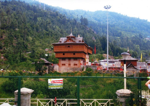
We drove down the very steep zig-zag road to Saltuji River and went to Sarahan. After checking in Hotel Srikhand at Sarahan, we visited the very unique Hindu Temple "Bimakali".
In Japan, all Buddist temples are constructed with wood. But in India, this is the first time for us to see the wooden Hindu temple like Bimakali.
Though Kinner is the very big mountain area with many 6000m peaks, there is only a few climbing records. I checked the climbing history in Kinner through The Himalayan Journal and other books and found that only eight peaks as below were already climbed.
1. Kinner Kailash (6050m ) : First ascent by British party in 1928.
2. Jorkarden (6473m) : First ascent by India ITBP party in 1974.
3. Phawrarang (6349m) : First ascent by India party in 1977.
4. Rangrik Rang (6553m) : First ascent by India-British Joint party in 1994.
5. Gangchhua (6288m) : First ascent by India Army party in 1974.
6. Manilang (6593m) : First ascent by British party in 1952.
7. Gangchhua (6030m) : First Ascent by Indian Army party in 1992.
8. Leo Pargil (6791m) : First Ascent by British party in 1933
IMF confirmed that there is no other climbing in Kinner area on their climbing record book.
Perhaps, the political situation did not allow to issue climbing permit in Kinner because of the border line problem with China.
The main purpose of our visit to Kinner in this summer is to explore the triangle mountain massif surrounded by three rivers, Baspa River, Sultuji River and Tirung Gad. There are many other veiled virgin peaks in this area, though only Kinner Kailash, Jorkarden, Phawararang and Rangrik Rang were already climbed.
 |
|
Hindlu Temple Bimakali in Sarahan
|
On June 17th (Tue):
We moved to Sangla from Sarahan. The main road along Sultuji River was damaged by the land sliding near Wangtu. We were obliged to go up about 600m from Wangtu on the local mountain road and traverse down to Urni spending extra one hour. We arrived in Sangla village around noon time. After lunch, we left Sangla to see the mountain peaks in the branches of Baspa Valley.
The first branch, Saro Garang, should have five big peaks like P5983, P5990, P6240, P6170, P6080 (Daboling ) on Leomann Maps. But we could not see any peaks, because Saro Garamg was high gorge and the top of the mountains was covered with cloud.
There should be P6080 (Daboling) and P6080 (Siro) on the top of the next branch, Gor Garang. But, unfortunately, we could not see any high peaks because of the same situation.
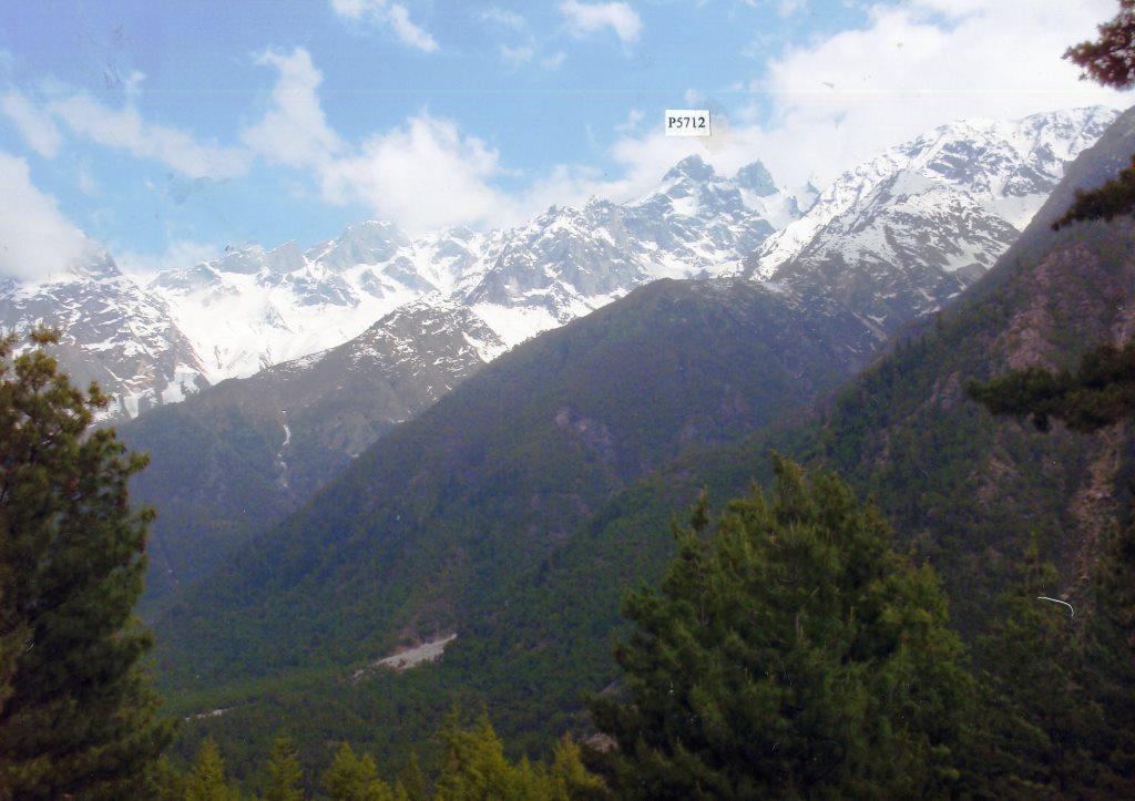
Another two branches, Mangna Nala and Sushang Nala were also the same situation and did not show any peaks. However, we could see the attractive twin peak P5712 in Sushang Nala, the other side branch of Baspa River. We went back from Mostrang to Hotel Srikhand in Sangla village.
.jpg)
 |
|
|
P5712 in Sushang Nala of Baspa River
|
|
 |
|
|
P6465 and P6447 near top of Baspa River (taken from Chitkul)
|
On June 18th (Wed):
We checked out Hotel Srikand in Sangla and drove to Chitkul, where we arrived around 9.15am. We could not see any high peaks in the branches, because of the same conditions as the previous day. The traffic road ended at Chitkul village. But a new road was under construction up to Mulung, as ITBP (India Tibet Border Police) camp was recently set up there. The new road was opened up to the half way to Mulung. Many soldiers carried foods and daily necessities on their back from Chitkul village.
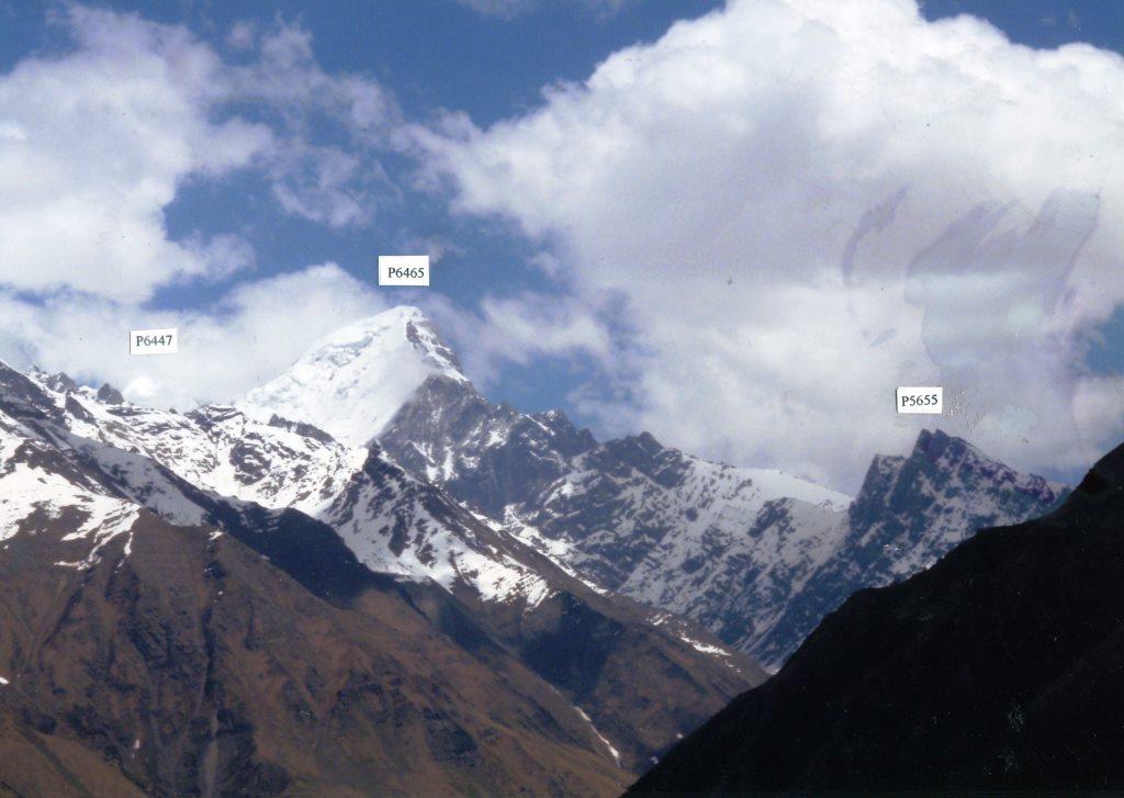
We expected to see P6465 and 6447 near the top of Baspa River, but we could not see them because of heavy cloud. Rangrik Rang (6553m) which was climbed by India-British Joint party in 1994 (Indian Leader was Haris Kapadia and British Leader was Chiris Bonington) should be located at the further East of P6447.
We waited about one hour on the hill near Mulung. The heavy cloud did not disappear, and P6465 and P6447 did not show up. We gave up seeing these mountains and went back to Chitkul village with disappointment.
After finishing lunch at the small restaurant in Chitkul, the cloud was cleared up. Finally we could see P6465 and P6447 from the front of the restaurant. We were so excited to see the whole attractive peak of P6465 and the head of P6467 peeping from the left side shoulder of P6465.
We were very happy to see these expected peaks. We moved to Kalpa by our chartered cars and checked in Hotel Grand Shangrila in Kalpa at 5:15pm. But, we could not see any peaks, as the mountain massif of Kinner Kailash was covered with the heavy cloud.
.jpg) |
|
P6465 in Baspa Valley (takem from Chitkul )
|
On June 19th (Thr):
We got up around 4:30am to see the high peaks of Kinner Kailash massif from the hotel terrace.
But, the mountains were still covered with dark cloud. After waiting about one hour, finally the sky cleared up and the mountain range of Kinner Kailash started to appear in the sun rise.
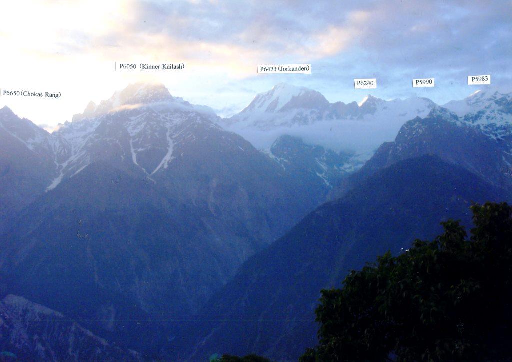
We enjoyed the nice view of high peaks. In Kinner Kailash massif, P6240, P5990 and P5983 on the west of Jorkanden are still untrodden according to the information from IMF.
After breakfast, we moved to Nako. We stopped in the lower town, Rekong Peo which is the capital in this area and the modernized town like the Switzerland village.
After about one hour drive, we reached Aren where we could have the view of the exciting rocky peaks in the east of Tirung Gad River : P6120 (Bisa Rang), P6248 (Saser Rang), P6120 (Beshrang) and P6209 (Shagchang Rang).
IMF confirmed us that these peaks are still unclimbed according to their climbing record book.
But, we wonder why these attractive mountains near the main traffic road have not been climbed yet and why the mountain names were already given to these unclimbed peaks.
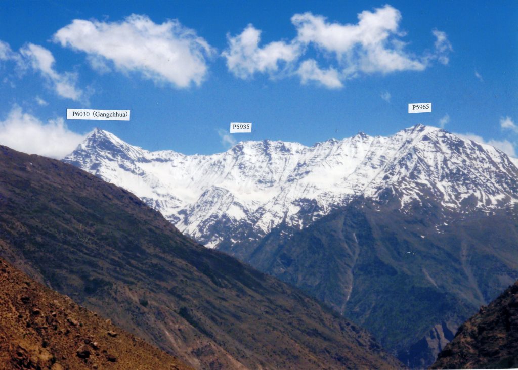
From Ka village, we could have the view of P6030 (Gangchuua), P5935 and P5965 in the branch called Tiang Lungpa.
In Phu village, we met one Japanese trekker. He said that the main traffic road from Kunzum La (4551m) to Chandra River was damaged by land sliding and closed, and so he was obliged to turn back from Kaja. Anyhow, we decided to proceed to Kaja as per our original schedule, expecting the traffic road would be repaired and re-opened before we arrive in Kaja.
We drove up on east side mountain road from Puh and reached Nako which was the very beautiful hill side village at 3660m with a lovely lake at 2:10pm.
We took a walk in the Nako village and could see from Nako Gompa P6791 (Leo Pargial) which is the rocky pinnacle standing on the border ridge between India and China. We could not see P6816 in the south of Leo Pargial from Nako village.
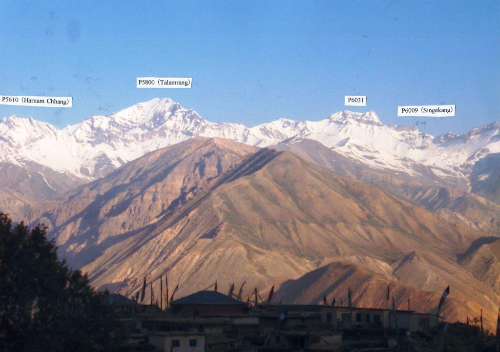
From the garden of Kinner Camps Nako, we could have the vast view of west mountains range on the other side of Hangrang Valley. P6000 (Singekang), P6031, P5800 (Talanrang) and P5610 (Harman Chhang) are standing on the top of Lipak Lungpa branch. These peaks are still unclimbed virgin peaks, referring to IMF information.
.jpg)
 |
|
Kinner Kailash massif (taken from Kalpa )
|
.jpg) |
|
Untrodden Peaks in Tirung Gad (taken from Alpa)
|
 |
|
P6030, P5935 and P5965 (taken from Ka)
|
%20from%20Nako%20Gompa%20(%20by%20Mr.%20Taniguchi).jpg) |
|
Leo Pargial (6791m) from Nako Gompa
|
 |
|
Virgin peaks on West of Nako (taken from Nako Village)
|
On June 20th (Fri):
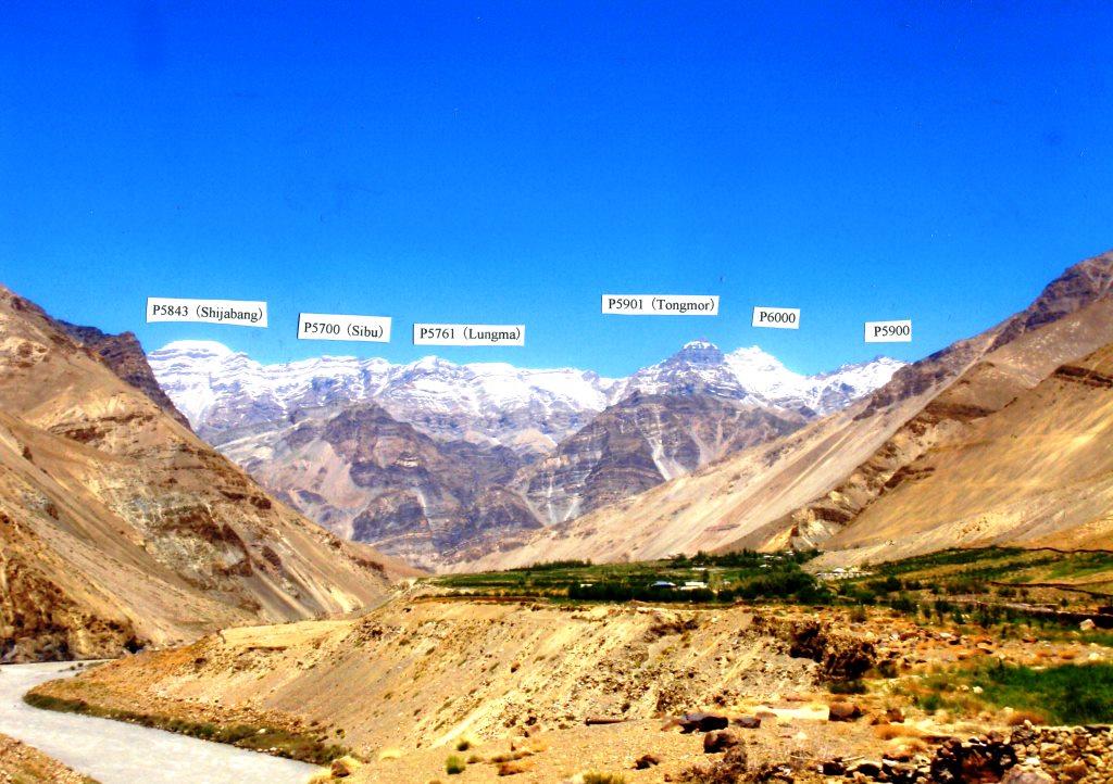
We left Nako at 7:40am and reached Tabo at 2:00pm after showing our passport and Inner Line Permit at Sumdo Check Post. Just before Tabo, we saw the mountain range with P6000, P5901 (Tongmor), P5761 (Lungma), P5700 (Sibu) and P5843 (Shijabang) on the north of Tabo village.
We visited Tabo Gompa, which was the small temple but had a lot of wonderful Buddist statues and the wall paintings in Kashimir style like the arts of Alchi Gompa in Ladakh.
We were so impressed with the high level Buddist arts.
 |
|
Mountain range on the north of Tabo village
|
On June 21st (Sat)
We left Tabo and visited Dankar Gompa and Lalung Gompa as one day tour. Dankar Gompa was a small temple and most of the wall Buddist paintings were unfortunately damaged.
After Dankar, we visited Lalung Gompa, which was also a small temple but had the very nice Buddhist wall paintings. Near Lalung Gompa, we could see the rocky mountain P5902 in the south west of Lalung Gompa.
On June 22nd (Sun):
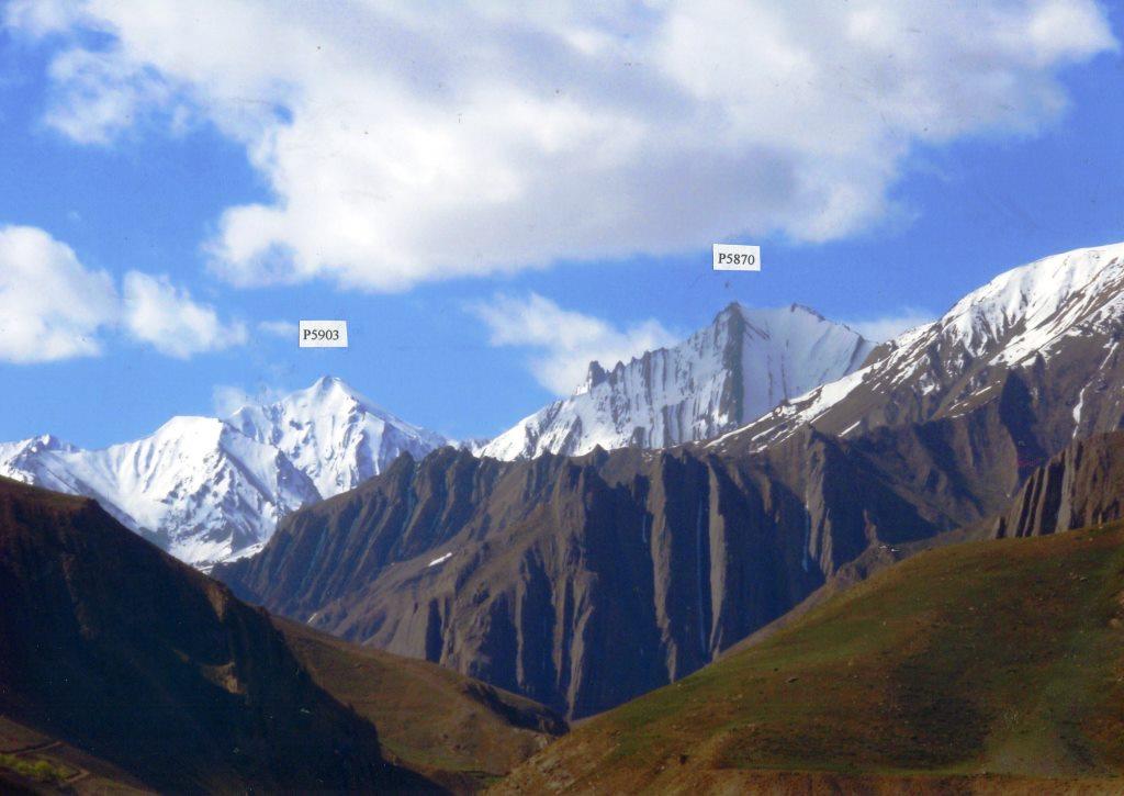
We left Tabo and drove up on the main road along Spiti River. After passing the junction of Spiti River and Pin River, we crossed Spity River at Lingti and turned back to the junction to Pin River. We paid a visit to Kungri Gompa which had new main building under the support of Dalai Lama 14th. After short drive from Kungri Gompa for about 20 minutes, we arrived in Sagnam village at 11:30am. We could see the attractive snow peaks P5903 and P5870 in Kuoki River, the branch of Pin River, from the entrance of Sagnam village.
After lunch at the local private house where we stayed, we had the short excursion to Mud by car. We reached Mud in about one hour drive and took a short hiking on the left branch of Pin River.
We turned back to Sagnam after one hour walk, as rain started suddenly.
.jpg)
.jpg)
.jpg)
.jpg)
 |
|
P5903 and P5870 in Kuoki Nala of Pin River (taken from Sagnam village)
|
On June 23rd (Mon):
We went to the right branch of Pin River. Before we came to Sagnam, we thought that we could go by car up to Gechang, as there was the traffic road reaching to Gechang on Leomann Maps.
But the village people of Sagnam told us that the traffic road ended at Kaa village, as the road to Gechang was damaged by land sliding and now it is abandoned.
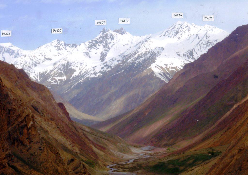
Therefore, we drove to Kaa and started walking in Parahio River to explore Debsa Nala at around 8:15am. There were two houses at Kaa. We went down on the steep narrow path from the village to Kidul Chu, the branch of Paraiho River, and then crossed this small river and traversed on the other side, by climbing up and down. Finally, we went down to flat Parahio River, spending more than one hour. Just before Thidim, we could see many challenging peaks in Debsa Nala, P5975, P6126, P6507, P6410, P6130, P6222, P6202 and P6243. Referring to the information from IMF, we suppose that all these high peaks are still untrodden and virgin peaks. We were overwhelmed with this marvelous mountains view.
Though we wished to peep into Khamengar Valley, there was no enough time left for us.
After lunch, we decided to go back and came back to the parking place at Kaa around 4:00pm.
We were very happy to have the nice view of the 6000m peaks in Debsa Nala. But it was a great regret that we could not see any mountains in Khamengar Valley. It was my mistake that we did not plan to spend two or three days to explore both Debsa Nala and Khamengar Valley with enough foods and tents.
 |
|
Untrodden Peaks in Debsa Nala of Pin River (taken near Thidim)
|
On June 24th (Tue):
We went to the left branch of Pin River again. We left Sagnam at 8:00am by cars and started to walk from Mud village. Left branch of Pin River is the very wide and open pasture with many goats. There are several grazing huts. We could enjoy the wonderful view of Pin River.
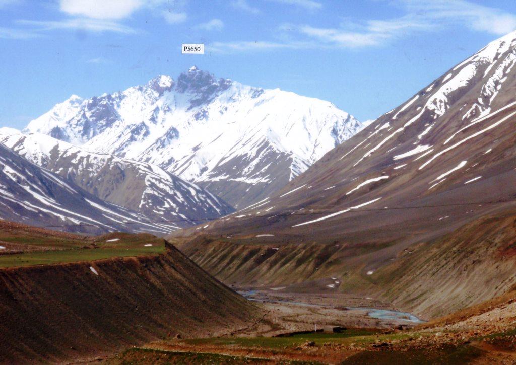
P5650 was sitting with the big bottom like a mother at the top of this branch. At the junction with the path coming down from Lalung La, we had lunch and left for Mud at 11:45am. It was the very pleasant walk.
 |
|
P5650 in the left branch of Pin River
|
On June 25th (Wed):
We left Sagnam at 7:40am and arrived in Kaja at 9:20 by the chartered cars. The master of the Hotel Spiti Sarai at Rangrik where we stayed told us that the main traffic road is still closed between Kunzum La and Chandra River. As nobody knew when the main traffic road would be opened, we gave up going back to Shimla via Rohtang Pass and Manali and decided to return to Shimla on the same way via Tabo, Nako and Kalpa.
After taking lunch at the hotel, we visited Ki Gompa on the top of the hill. Then, we went to Langia which is the very beautiful pasture with several local houses. We saw the white snow peak "Chau Chau (6303)", which was first climbed by British party in 1993.
On the other side of Spiti River, we could see Ratang Tower (6170m) which was first climbed Indian Party (Leader: Haris Kapadia) in 1993 and the untrodden peak P6060 in the branch Ratang River. On the left side of Ratang River, we could see P5877 which looked like Mt. Alberta in Canadian Rocky.
.jpg)
%20taken%20from%20Langia.jpg) |
|
P6303 (Chau Chau) taken from Langia
|
.jpg) |
|
Ratang Tower and P6060 in Ratang River( taken from Langia )
|
.jpg) |
|
P5685 and P5877 on left side of Ratang River (taken from Langia)
|
On June 26th (Thr):
The other members except me took a walk in Rangrik village. I took rest as I am suffering diarrhea.
On June 27th (Fri) ~ 29th (Sun):
We left Rangrik of Kaja and drove back to Shimla, via Nako, Kalpa and Rampur, spending three days. We were very exhausted by the long drive.
On June 30th, we enjoyed the sightseeing in Shimla. And on July 1st, we went back to Delhi by train. After two nights stay in Delhi, we left Delhi for Japan on July 3rd and came back to Japan on July 4th.
We were very happy to see many attractive unknown mountains in Kinner and Spiti. These areas are very big. I regret that I made a plan to explore these big areas in very short time. We should try again to have more detail exploration of one or two limited places with enough days next time.
This summer, again, we used the agent "Hidden Himalaya, Leh ". We would like to express our sincere thankfulness to Mr.Tsewang Yangphel for his best support on all the way of our exploration.